
I Sestieri di Venezia - The Districts of Venice
La Guide ai Sestieri - The guide to the Districts
ITALIANO -
Fin dalle sue origini Venezia è divisa in 6 Sestieri, che corrispondono ai Quartieri delle altre Città. Il Quartiere rappresenta una porzione di territorio dotata di un certo grado di autonomia amministrativa e il termine indica il numero di settori (quattro) in cui erano ripartite le città medioevali. Questa impostazione fu utilizzata fin dagli antichi romani per suddividere un accampamento militare (castrum) in quattro settori grazie all’intersezione di due strade principali, il “cardo e il “decumano”. Venezia per la sua particolare conformazione urbana rappresenta un’eccezione, infatti la suddivisione non venne fatta in quartieri, ma in sestieri, che altro non sono se non i sei settori che compongono il centro storico di Venezia. Ogni Sestiere era governato da un Consigliere Ducale eletto dal Minor Consiglio, e la sorveglianza era deputata a dei funzionari chiamati Capisestiere, incaricati di riferire puntualmente al governo sull'identità e il comportamento dei cittadini residenti. La suddivisione in sestieri era spesso estesa anche ai territori sotto il controllo della Repubblica di Venezia, che venivano in tal modo associati ad uno dei rioni cittadini, come nei casi dell'isola di Creta e dei territori del Dogado.
Particolare sono le assegnazioni dei numeri civici su calli, campi e piazze ed è unica per ogni Sestiere. Inizia con il numero 1 e prosegue fino ad arrivare a numeri di quattro cifre (il Sestiere di Castello raggiunge quasi i 7000 numeri). La complessità della viabilità e del sistema di numerazione, porta talvolta ad avere due numeri civici molto diversi o addirittura uguali, a poca distanza tra loro.
A livello simbolico i Sestieri sono rappresentati da 6 denti anteriori del “Ferro da Prua” (tipica decorazione della Gondola) e, assieme al dente posteriore rappresentativo dell'isola della Giudecca, alla forma a S ricalcante il percorso del Canal Grande, al piccolo arco sopra l'ultima sbarra che ricorda il Ponte di Rialto, e all'ampia voluta superiore indicante insieme il Bacino San Marco e il Corno Ducale (copricapo del Doge), vanno a fornire la rappresentazione stilizzata della città.
ENGLISH -
Since its origins Venice has been divided into 6 Sestieri, which correspond to the Districts of the other Cities. The district represents a portion of the territory endowed with a certain degree of administrative autonomy and the term indicates the number of sectors (four) in which the medieval cities were divided. This setting was used since the ancient Romans to divide a military camp (castrum) into four sectors thanks to the intersection of two main roads, the "cardo and the" decumano ". Venice due to its particular urban conformation is an exception, in fact the subdivision was not made into neighborhoods, but into sestieri, which are none other than the six sectors that make up the historic center of Venice. Each district was governed by a ducal councilor elected by the minor council, and the surveillance was delegated to officials called district managers, in charge of promptly reporting to the government on the identity and behavior of resident citizens. The subdivision into sestieri was often also extended to the territories under the control of the Republic of Venice, which were thus associated with one of the city districts, as in the cases of the island of Crete and the territories of the Dogado.
Particular are the assignments of house numbers on streets, fields and squares and it is unique for each Sestiere. It starts with the number 1 and continues until you get to four-digit numbers (the Sestiere di Castello reaches almost 7000 numbers). The complexity of the roads and the numbering system sometimes leads to having two very different or even identical house numbers, a short distance from each other.
On a symbolic level, the Sestieri are represented by 6 front teeth of the "Ferro da Prua" (typical decoration of the Gondola) and, together with the rear tooth representing the Giudecca island, the S-shape tracing the path of the Grand Canal, the small arch above the last bar that recalls the Rialto Bridge, and the large upper volute indicating both the San Marco Basin and the Doge's Horn (Doge's headgear), provide the stylized representation of the city.
ITALIANO
È il Sestiere più popolato di Venezia e il secondo, dopo quello di Castello, come grandezza. Sull’’origine del nome ci sono varie ipotesi, quella confermata che derivi dai vasti “Canneti” (terreno acquitrinoso o argilloso occupato da graminacee) presenti quando la zona era ancora disabitata. Un’altra ipotesi che derivi dal nome del canale principale, Canal Cannaregio, inizialmente chiamato Canal Regio. Un’ultima ipotesi che derivi dal nome latino “canaliculus” (piccolo canale) un piccolo corso d’acqua che attraversa il sestiere e sfocia in Laguna.
Da questo Sestiere fu realizzato il primo collegamento terrestre tra Venezia e la terraferma, con la costruzione della Stazione Ferroviaria di Santa Lucia.
Qui vissero grandi personaggi storici, tra i quali Marco Polo, Tintoretto e Tiziano.
Cosa vedere:
- Chiesa di Santa Maria di Nazaret (Chiesa degli Scalzi)
- Santuario di Santa Lucia
- Palazzo Labia
- Palazzo Savorgnan
- Ponte delle Guglie
- Ponte dei Tre Archi
- Quartiere Ebraico
- Ghetto Vecchio
- Ghetto Nuovo
- Museo Ebraico
- Chiesa della Madonna dell’Orto
- Casa del Tintoretto
- Scuola Grande di Santa Maria della Misericordia
- Casinò di Venezia
- Ponte del Chiodo
- Ca’ d’Oro
- Chiesa di Santa Maria dei Miracoli
- Calle Varisco
- Chiesa dei Gesuiti
ENGLISH
It is the most populated district of Venice and the second, after that of Castello, in size. There are various hypotheses on the origin of the name, the one confirmed that it derives from the vast "Reeds" (marshy or clayey soil occupied by grasses) present when the area was still uninhabited. Another hypothesis that derives from the name of the main canal, Canal Cannaregio, initially called Canal Regio. A final hypothesis that derives from the Latin name "canaliculus" (small canal) a small stream that crosses the district and flows into the lagoon.
From this Sestiere the first land connection between Venice and the mainland was made, with the construction of the Santa Lucia railway station.
Great historical figures lived here, including Marco Polo, Tintoretto and Titian.
What see:
- Church of Santa Maria di Nazaret (Church of the Scalzi)
- Sanctuary of Santa Lucia
- Palazzo Labia
- Savorgnan Palace
- Ponte delle Guglie
- Ponte dei Tre Archi
- Jewish Quarter
- Old Ghetto
- New Ghetto
- Jewish Museum
- Church of the Madonna dell’Orto
- House of Tintoretto
- Great School of Santa Maria della Misericordia
- Casino of Venice
- Ponte del Chiodo
- Ca 'd'Oro
- Church of Santa Maria dei Miracoli
- Calle Varisco
- Jesuit Church
84 Recomendado por los habitantes de la zona
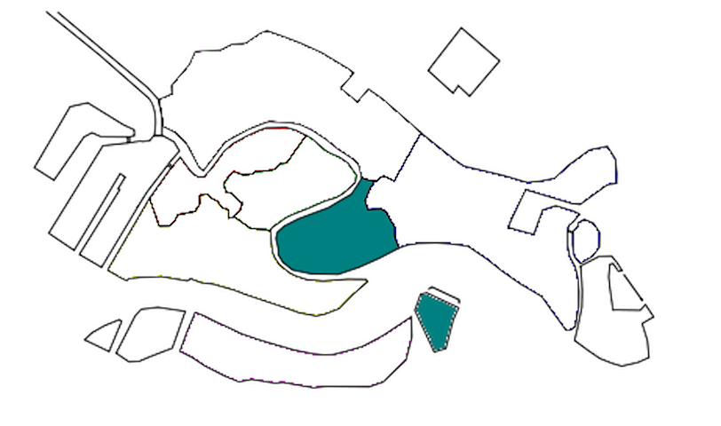
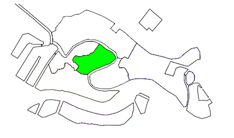
Cannaregio
ITALIANO
È il Sestiere più popolato di Venezia e il secondo, dopo quello di Castello, come grandezza. Sull’’origine del nome ci sono varie ipotesi, quella confermata che derivi dai vasti “Canneti” (terreno acquitrinoso o argilloso occupato da graminacee) presenti quando la zona era ancora disabitata. Un’altra ipotesi che derivi dal nome del canale principale, Canal Cannaregio, inizialmente chiamato Canal Regio. Un’ultima ipotesi che derivi dal nome latino “canaliculus” (piccolo canale) un piccolo corso d’acqua che attraversa il sestiere e sfocia in Laguna.
Da questo Sestiere fu realizzato il primo collegamento terrestre tra Venezia e la terraferma, con la costruzione della Stazione Ferroviaria di Santa Lucia.
Qui vissero grandi personaggi storici, tra i quali Marco Polo, Tintoretto e Tiziano.
Cosa vedere:
- Chiesa di Santa Maria di Nazaret (Chiesa degli Scalzi)
- Santuario di Santa Lucia
- Palazzo Labia
- Palazzo Savorgnan
- Ponte delle Guglie
- Ponte dei Tre Archi
- Quartiere Ebraico
- Ghetto Vecchio
- Ghetto Nuovo
- Museo Ebraico
- Chiesa della Madonna dell’Orto
- Casa del Tintoretto
- Scuola Grande di Santa Maria della Misericordia
- Casinò di Venezia
- Ponte del Chiodo
- Ca’ d’Oro
- Chiesa di Santa Maria dei Miracoli
- Calle Varisco
- Chiesa dei Gesuiti
ENGLISH
It is the most populated district of Venice and the second, after that of Castello, in size. There are various hypotheses on the origin of the name, the one confirmed that it derives from the vast "Reeds" (marshy or clayey soil occupied by grasses) present when the area was still uninhabited. Another hypothesis that derives from the name of the main canal, Canal Cannaregio, initially called Canal Regio. A final hypothesis that derives from the Latin name "canaliculus" (small canal) a small stream that crosses the district and flows into the lagoon.
From this Sestiere the first land connection between Venice and the mainland was made, with the construction of the Santa Lucia railway station.
Great historical figures lived here, including Marco Polo, Tintoretto and Titian.
What see:
- Church of Santa Maria di Nazaret (Church of the Scalzi)
- Sanctuary of Santa Lucia
- Palazzo Labia
- Savorgnan Palace
- Ponte delle Guglie
- Ponte dei Tre Archi
- Jewish Quarter
- Old Ghetto
- New Ghetto
- Jewish Museum
- Church of the Madonna dell’Orto
- House of Tintoretto
- Great School of Santa Maria della Misericordia
- Casino of Venice
- Ponte del Chiodo
- Ca 'd'Oro
- Church of Santa Maria dei Miracoli
- Calle Varisco
- Jesuit Church
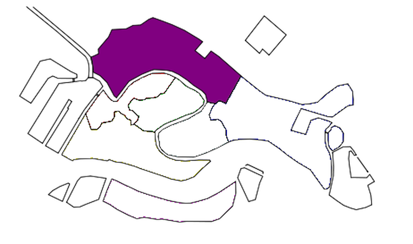
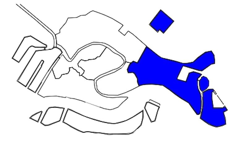
ITALIANO
È il Sestiere più esteso e Orientale di Venezia e il secondo più popolato e deve il suo nome al Castello che venne costruito qui sull’isola di Olivolo (oggi isola si San Pietro) nell’alto medioevo per proteggersi dagli attacchi via terra e per monitorare la situazione via mare. Il forte doveva inizialmente sorgere dove oggi si trova l’Arsenale e far parte probabilmente di un sistema difensivo più articolato comprendente una seconda fortificazione vicino Palazzo Ducale e una cinta muraria per difendere la città dalle invasioni degli Ungari tra il IX e X secolo.
Alle origini era diviso nelle due isole Gemine (il nome deriva per la presenza di due isole vicine) e l’isola di Olivolo (nome deriva probabilmente dalla forma a oliva dell’isola), unite in seguito a costituire il Sestiere.
Fu sede della prima Diocesi autenticamente Veneziana e della prima Cattedrale dedicata a San Pietro. È l’unico Sestiere che non si affaccia sul Canal Grande e rappresenta una delle zone meno visitate dai turisti mantenendo nel tempo la sua autenticità.
Cosa vedere:
- Basilica di San Pietro in Castello
- Canale di San Pietro
- Giardino delle Vergini
- Giardini di Garibaldi
- Chiesa di San Giuseppe di Castello
- Giardini Napoleonici (o della Biennale)
- Riva dei Sette Martiri
- Museo Storico Navale
- Arsenale
- Chiesa di San Francesco della Vigna
- Scuola Dalmata dei Santi Giorgio e Trifone
- Istituto Ellenico
- Riva degli Schiavoni
- Chiesa San Giovanni Battista in Bragora
- Chiesa di San Giorgio dei Greci
- Chiesa di San Zaccaria
- Libreria Acqua Alta
- Basilica di San Giovanni e Paolo
- Chiesa di Santa Maria Formosa
- Palazzo Querini Stampalia
- L’Arco del Paradiso
ENGLISH
It is the largest and easternmost district of Venice and the second most populated and owes its name to the Castle that was built here on the island of Olivolo (today the island of San Pietro) in the early Middle Ages to protect itself from land attacks and to monitor the situation by sea. The fort was originally supposed to rise where the Arsenal is located today and was probably part of a more complex defensive system including a second fortification near the Doge's Palace and a wall to defend the city from invasions by the Hungarians between the 9th and 10th centuries.
Originally it was divided into the two Gemine islands (the name derives from the presence of two neighboring islands) and the island of Olivolo (the name probably derives from the olive shape of the island), later joined to form the Sestiere.
It was the seat of the first authentically Venetian Diocese and of the first Cathedral dedicated to St. Peter. It is the only district that does not overlook the Grand Canal and is one of the least visited areas by tourists, maintaining its authenticity over time.
What see:
- Basilica of San Pietro in Castello
- Canal of San Pietro
- Garden of the Virgins
- Gardens of Garibaldi
- Church of San Giuseppe di Castello
- Napoleonic Gardens (or of the Biennale)
- Riva dei Sette Martiri
- Naval History Museum
- Arsenal
- Church of San Francesco della Vigna
- Dalmatian School of Saints George and Tryphon
- Hellenic Institute
- Riva degli Schiavoni
- Church of San Giovanni Battista in Bragora
- Church of San Giorgio dei Greci
- Church of San Zaccaria
- Acqua Alta bookshop
- Basilica of San Giovanni e Paolo
- Church of Santa Maria Formosa
- Palazzo Querini Stampalia
- The Arch of Paradise
57 Recomendado por los habitantes de la zona
Castello
ITALIANO
È il Sestiere più esteso e Orientale di Venezia e il secondo più popolato e deve il suo nome al Castello che venne costruito qui sull’isola di Olivolo (oggi isola si San Pietro) nell’alto medioevo per proteggersi dagli attacchi via terra e per monitorare la situazione via mare. Il forte doveva inizialmente sorgere dove oggi si trova l’Arsenale e far parte probabilmente di un sistema difensivo più articolato comprendente una seconda fortificazione vicino Palazzo Ducale e una cinta muraria per difendere la città dalle invasioni degli Ungari tra il IX e X secolo.
Alle origini era diviso nelle due isole Gemine (il nome deriva per la presenza di due isole vicine) e l’isola di Olivolo (nome deriva probabilmente dalla forma a oliva dell’isola), unite in seguito a costituire il Sestiere.
Fu sede della prima Diocesi autenticamente Veneziana e della prima Cattedrale dedicata a San Pietro. È l’unico Sestiere che non si affaccia sul Canal Grande e rappresenta una delle zone meno visitate dai turisti mantenendo nel tempo la sua autenticità.
Cosa vedere:
- Basilica di San Pietro in Castello
- Canale di San Pietro
- Giardino delle Vergini
- Giardini di Garibaldi
- Chiesa di San Giuseppe di Castello
- Giardini Napoleonici (o della Biennale)
- Riva dei Sette Martiri
- Museo Storico Navale
- Arsenale
- Chiesa di San Francesco della Vigna
- Scuola Dalmata dei Santi Giorgio e Trifone
- Istituto Ellenico
- Riva degli Schiavoni
- Chiesa San Giovanni Battista in Bragora
- Chiesa di San Giorgio dei Greci
- Chiesa di San Zaccaria
- Libreria Acqua Alta
- Basilica di San Giovanni e Paolo
- Chiesa di Santa Maria Formosa
- Palazzo Querini Stampalia
- L’Arco del Paradiso
ENGLISH
It is the largest and easternmost district of Venice and the second most populated and owes its name to the Castle that was built here on the island of Olivolo (today the island of San Pietro) in the early Middle Ages to protect itself from land attacks and to monitor the situation by sea. The fort was originally supposed to rise where the Arsenal is located today and was probably part of a more complex defensive system including a second fortification near the Doge's Palace and a wall to defend the city from invasions by the Hungarians between the 9th and 10th centuries.
Originally it was divided into the two Gemine islands (the name derives from the presence of two neighboring islands) and the island of Olivolo (the name probably derives from the olive shape of the island), later joined to form the Sestiere.
It was the seat of the first authentically Venetian Diocese and of the first Cathedral dedicated to St. Peter. It is the only district that does not overlook the Grand Canal and is one of the least visited areas by tourists, maintaining its authenticity over time.
What see:
- Basilica of San Pietro in Castello
- Canal of San Pietro
- Garden of the Virgins
- Gardens of Garibaldi
- Church of San Giuseppe di Castello
- Napoleonic Gardens (or of the Biennale)
- Riva dei Sette Martiri
- Naval History Museum
- Arsenal
- Church of San Francesco della Vigna
- Dalmatian School of Saints George and Tryphon
- Hellenic Institute
- Riva degli Schiavoni
- Church of San Giovanni Battista in Bragora
- Church of San Giorgio dei Greci
- Church of San Zaccaria
- Acqua Alta bookshop
- Basilica of San Giovanni e Paolo
- Church of Santa Maria Formosa
- Palazzo Querini Stampalia
- The Arch of Paradise
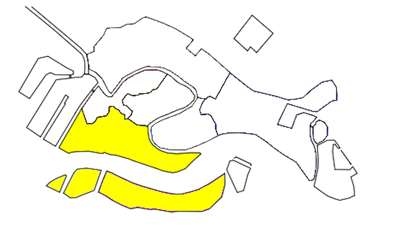
ITALIANO
È il Sestiere più Meridionale della città, deve il suo nome perchè anticamente sorgeva in una zona poco paludosa con terreno più saldo rispetto al resto del territorio, aveva il “dorso più duro”. Tra le primissime zone della città che furono colonizzate, fu nella parte occidentale l’isola di Mendigola. L’area dell’isola è identificata oggi dove fu eretta, nel VII secolo, la Chiesa di San Nicolò dei Mendicoli, una delle più antiche della città. Il nome della Chiesa si pensa possa arrivare da Mendigola (il vecchio nome dell’isola) o da Mendici (indicava il modesto tenore di vita della contrada). Proprio in quest’area della città lagunare vivevano i “Nicolotti”, cioè una delle due fazioni di lavoratori dell’Arsenale di Venezia. Erano sempre in forte rivalità con l’altra fazione di lavoratori i “Castellani” (abitanti del Sestiere di Castello e in parte di quello di San Marco). Le due fazioni si sfidavano molte volte a mani nude nei Ponti dei Pugni (quello più conosciuto si trova in Campo San Barnaba, sempre nel Sestiere di Dorsoduro), veri e propri luoghi di battaglia senza balaustre di protezione, vinceva chi per primo raggiungeva l’altra sponda del ponte. Il Governo stesso di Venezia fomentava questa rivalità per aver sempre uomini allenati al combattimento.
Fanno parte del territorio anche il Canale della Giudecca e l’omonima isola, che amministrativamente è considerata parte del Sestiere, ma ha una propria numerazione civica.
Il Sestiere è una zona Universitaria, per la presenza massiccia delle maggiori Università di Venezia e secondo solo al Sestiere di San Marco come collocazione di Chiese, Palazzi e Musei.
Cosa vedere:
- Chiesa di San Pantalon
- Campo Santa Margherita
- Giardini di Ca’ Rezzonico
- Ponte dei Pugni
- Chiesa dei Carmini
- Chiesa di San Nicolò dei Mendicoli
- Chiesa dell’Angelo Raffaele
- Chiesa di San Sebastiano
- Squero di San Trovaso
- Gallerie dell’Accademia
- Ponte dell’Accademia
- Collezione Peggy Guggenheim
- Palazzo Dario
- Ex Chiesa di San Gregorio
- Basilica Santa Maria della Salute
- Punta della Dogana
- Magazzini del Sale
- L’Isola della Giudeca
ENGLISH
It is the southernmost district of the city, it owes its name because in ancient times it stood in a little swampy area with firmer ground than the rest of the territory, it had the "hardest back". One of the very first areas of the city that were colonized was the island of Mendigola in the western part. The area of the island is identified today where the Church of San Nicolò dei Mendicoli was erected in the seventh century, one of the oldest in the city. The name of the Church is thought to come from Mendigola (the old name of the island) or from Mendici (it indicated the modest standard of living of the district). It was in this area of the lagoon city that the "Nicolotti" lived, that is, one of the two factions of workers of the Venice Arsenal. The "Castellani" (inhabitants of the Castello district and in part of that of San Marco) were always in strong rivalry with the other faction of workers. The two factions challenged each other many times with their bare hands in the Ponti dei Pugni (the best known is in Campo San Barnaba, also in the Dorsoduro district), real battlegrounds without protective balustrades, the one who first reached the other side of the bridge. The Government of Venice itself fomented this rivalry by always having men trained in combat.
The Giudecca Canal and the island of the same name are also part of the territory, which is administratively considered part of the Sestiere, but has its own street number.
The Sestiere is a university area, due to the massive presence of the major universities of Venice and second only to the Sestiere of San Marco as a location for churches, palaces and museums.
What see:
- Church of San Pantalon
- Campo Santa Margherita
- Gardens of Ca 'Rezzonico
- Bridge of Fists
- Church of the Carmini
- Church of San Nicolò dei Mendicoli
- Church of the Angelo Raffaele
- Church of San Sebastiano
- Squero di San Trovaso
- Accademia Galleries
- Ponte dell’Accademia
- Peggy Guggenheim Collection
- Palazzo Dario
- Former Church of San Gregorio
- Basilica of Santa Maria della Salute
- Punta della Dogana
- Salt Warehouses
- The Giudeca Island
43 Recomendado por los habitantes de la zona
Dorsoduro
Sestiere di DorsoduroITALIANO
È il Sestiere più Meridionale della città, deve il suo nome perchè anticamente sorgeva in una zona poco paludosa con terreno più saldo rispetto al resto del territorio, aveva il “dorso più duro”. Tra le primissime zone della città che furono colonizzate, fu nella parte occidentale l’isola di Mendigola. L’area dell’isola è identificata oggi dove fu eretta, nel VII secolo, la Chiesa di San Nicolò dei Mendicoli, una delle più antiche della città. Il nome della Chiesa si pensa possa arrivare da Mendigola (il vecchio nome dell’isola) o da Mendici (indicava il modesto tenore di vita della contrada). Proprio in quest’area della città lagunare vivevano i “Nicolotti”, cioè una delle due fazioni di lavoratori dell’Arsenale di Venezia. Erano sempre in forte rivalità con l’altra fazione di lavoratori i “Castellani” (abitanti del Sestiere di Castello e in parte di quello di San Marco). Le due fazioni si sfidavano molte volte a mani nude nei Ponti dei Pugni (quello più conosciuto si trova in Campo San Barnaba, sempre nel Sestiere di Dorsoduro), veri e propri luoghi di battaglia senza balaustre di protezione, vinceva chi per primo raggiungeva l’altra sponda del ponte. Il Governo stesso di Venezia fomentava questa rivalità per aver sempre uomini allenati al combattimento.
Fanno parte del territorio anche il Canale della Giudecca e l’omonima isola, che amministrativamente è considerata parte del Sestiere, ma ha una propria numerazione civica.
Il Sestiere è una zona Universitaria, per la presenza massiccia delle maggiori Università di Venezia e secondo solo al Sestiere di San Marco come collocazione di Chiese, Palazzi e Musei.
Cosa vedere:
- Chiesa di San Pantalon
- Campo Santa Margherita
- Giardini di Ca’ Rezzonico
- Ponte dei Pugni
- Chiesa dei Carmini
- Chiesa di San Nicolò dei Mendicoli
- Chiesa dell’Angelo Raffaele
- Chiesa di San Sebastiano
- Squero di San Trovaso
- Gallerie dell’Accademia
- Ponte dell’Accademia
- Collezione Peggy Guggenheim
- Palazzo Dario
- Ex Chiesa di San Gregorio
- Basilica Santa Maria della Salute
- Punta della Dogana
- Magazzini del Sale
- L’Isola della Giudeca
ENGLISH
It is the southernmost district of the city, it owes its name because in ancient times it stood in a little swampy area with firmer ground than the rest of the territory, it had the "hardest back". One of the very first areas of the city that were colonized was the island of Mendigola in the western part. The area of the island is identified today where the Church of San Nicolò dei Mendicoli was erected in the seventh century, one of the oldest in the city. The name of the Church is thought to come from Mendigola (the old name of the island) or from Mendici (it indicated the modest standard of living of the district). It was in this area of the lagoon city that the "Nicolotti" lived, that is, one of the two factions of workers of the Venice Arsenal. The "Castellani" (inhabitants of the Castello district and in part of that of San Marco) were always in strong rivalry with the other faction of workers. The two factions challenged each other many times with their bare hands in the Ponti dei Pugni (the best known is in Campo San Barnaba, also in the Dorsoduro district), real battlegrounds without protective balustrades, the one who first reached the other side of the bridge. The Government of Venice itself fomented this rivalry by always having men trained in combat.
The Giudecca Canal and the island of the same name are also part of the territory, which is administratively considered part of the Sestiere, but has its own street number.
The Sestiere is a university area, due to the massive presence of the major universities of Venice and second only to the Sestiere of San Marco as a location for churches, palaces and museums.
What see:
- Church of San Pantalon
- Campo Santa Margherita
- Gardens of Ca 'Rezzonico
- Bridge of Fists
- Church of the Carmini
- Church of San Nicolò dei Mendicoli
- Church of the Angelo Raffaele
- Church of San Sebastiano
- Squero di San Trovaso
- Accademia Galleries
- Ponte dell’Accademia
- Peggy Guggenheim Collection
- Palazzo Dario
- Former Church of San Gregorio
- Basilica of Santa Maria della Salute
- Punta della Dogana
- Salt Warehouses
- The Giudeca Island
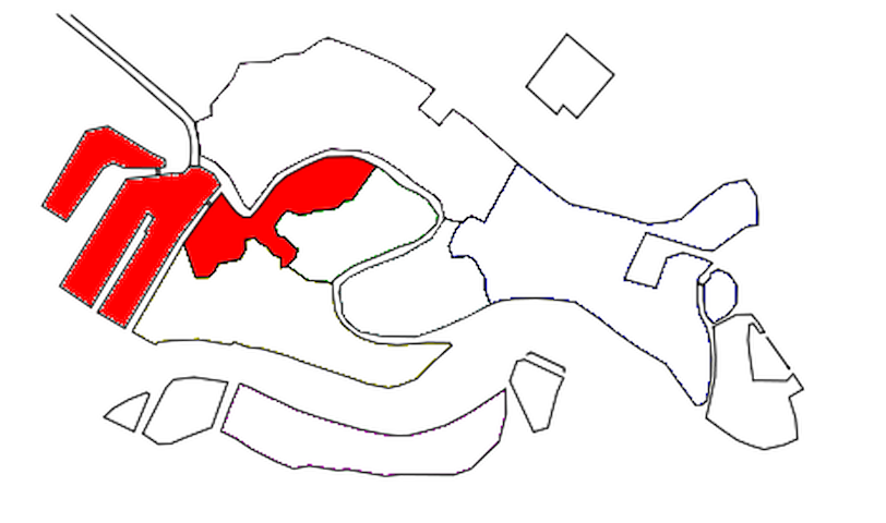
ITALIANO
È il più piccolo dei Sestieri di Venezia ed è la “porta d’ingresso” per chi arriva dalla terraferma. È l’unico Sestiere ad avere una zona (Piazzale Roma), seppur limitata, in cui è permesso alle vetture di circolare. Prende il nome dall'antichissima Chiesa di Santa Croce, il cui impianto originale risaliva al VII secolo e fu demolita nella prima metà del IX secolo dopo le soppressioni Napoleoniche. Della Chiesa rimane solo una colonna, attualmente incorporata nel muro che circonda i Giardini Papadopoli. I Giardini sono l’unica area verde rimasta per una intensiva attività di edilizia popolare dopo la costruzione della Stazione Ferroviaria di Santa Lucia.
Il Sestiere Santa Croce in origine occupava un’area periferica della Città (Venezia si poteva raggiungere solo in barca, approdando alla Fondamenta delle Zattere nel Sestiere di Dorsoduro), scarsamente popolato ed era una zona puramente di paludi e saline chiamata “Luprio”, perché forse infestata da Lupi. Successivamente venne bonificata per la coltivazione di Orti e Vigne. Il suo sviluppo cominciò dalla metà del XIX secolo con la costruzione del Ponte Ferroviario prima e nel 1933 con la costruzione del “Ponte Littorio” (Ponte della Libertà) durante il Regime Fascista. È il Sestiere che più di qualsiasi altro nel XX secolo ha subito l’impatto da questi collegamenti, prima con la realizzazione della Stazione Marittima e in successione con la creazione dell'area di Piazzale Roma, l'apertura del Rio Novo e la costruzione del parcheggio-isola artificiale del Tronchetto, che hanno trasformato la parte nord del sestiere nel terminal automobilistico e dei bus nella città lagunare.
Il Sestiere è caratterizzato da Calli strette intervallate da pochi Campi ed è l’unico sestiere di Venezia ad unire l’antico, il moderno e il contemporaneo. Non è ricco di attrazioni e monumenti, ma non per questo meno interessante artisticamente e architettonicamente.
Cosa vedere:
- People Mover (sistema di trasporto che collega l’Isola del Tronchetto a Piazzale Roma)
- Cittadella della Giustizia
- Ex Chiesa di Sant’Andrea della Zirada
- Ponte della Costituzione
- Chiesa di San Simeon Piccolo
- Ponte degli Scalzi
- Chiesa di San Simeon Grando
- Fontego dei Turchi (Museo di Storia Naturale)
- Chiesa di San Zan Degolà (Chiesa di San Giovanni Battista Decollato)
- Chiesa di San Giacomo dell’Orio
- Fontego del Mégio
- Palazzo Belloni Battagia
- Chiesa di San Stae
- Palazzo Ca’ Pesaro (Museo d’Arte Orientale e Galleria Internazionale d’Arte Moderna)
- Museo di Palazzo Mocenigo (Museo del Tessuto, del Costume e del Profumo)
- Palazzo Ca’ Corner della Regina (sede della Fondazione Prada)
- Chiesa di San Nicola di Tolentino
- Calle Ca’ Zusto (larga 65cm)
- Chiesa di San Cassian
- Chiesa di Santa Maria Mater Domini
ENGLISH
It is the smallest of the Venice Sestieri and is the "gateway" for those arriving from the mainland. It is the only Sestiere to have an area (Piazzale Roma), albeit limited, in which cars are allowed to circulate. It takes its name from the ancient Church of Santa Croce, whose original structure dates back to the 7th century and was demolished in the first half of the 9th century after the Napoleonic suppressions. Of the Church only a column remains, currently incorporated into the wall that surrounds the Papadopoli Gardens. The Gardens are the only green area left for intensive public housing activity after the construction of the Santa Lucia railway station.
The Sestiere Santa Croce originally occupied a peripheral area of the city (Venice could only be reached by boat, landing at the Fondamenta delle Zattere in the Dorsoduro district), sparsely populated and was an area purely of marshes and salt marshes called "Luprio", because possibly haunted by wolves. Later it was reclaimed for the cultivation of Orti and Vigne. Its development began in the mid-nineteenth century with the construction of the Railway Bridge first and in 1933 with the construction of the "Ponte Littorio" (Ponte della Libertà) during the Fascist regime. It is the Sestiere that more than any other in the twentieth century suffered the impact of these connections, first with the construction of the Maritime Station and subsequently with the creation of the Piazzale Roma area, the opening of the Rio Novo and the construction of the Tronchetto artificial parking-island, which transformed the northern part of the district into the car and bus terminal in the lagoon city.
The Sestiere is characterized by narrow calli interspersed with a few fields and is the only district in Venice to combine the ancient, the modern and the contemporary. It is not rich in attractions and monuments, but no less interesting artistically and architecturally.
What see:
- People Mover (transport system that connects Tronchetto Island to Piazzale Roma)
- Citadel of Justice
- Former Church of Sant’Andrea della Zirada
- Constitution Bridge
- Church of San Simeon Piccolo
- Ponte degli Scalzi
- Church of San Simeon Grando
- Fontego dei Turchi (Natural History Museum)
- Church of San Zan Degolà (Church of San Giovanni Battista Decollato)
- Church of San Giacomo dell’Orio
- Fontego del Mégio
- Palazzo Belloni Battagia
- Church of San Stae
- Palazzo Ca' Pesaro (Museum of Oriental Art and International Gallery of Modern Art)
- Museum of Palazzo Mocenigo (Museum of Fabric, Costume and Perfume)
- Palazzo Ca' Corner della Regina (headquarters of the Prada Foundation)
- Church of San Nicola di Tolentino
- Calle Ca' Zusto (65cm wide)
- Church of San Cassian
- Church of Santa Maria Mater Domini
18 Recomendado por los habitantes de la zona
Santa Croce
ITALIANO
È il più piccolo dei Sestieri di Venezia ed è la “porta d’ingresso” per chi arriva dalla terraferma. È l’unico Sestiere ad avere una zona (Piazzale Roma), seppur limitata, in cui è permesso alle vetture di circolare. Prende il nome dall'antichissima Chiesa di Santa Croce, il cui impianto originale risaliva al VII secolo e fu demolita nella prima metà del IX secolo dopo le soppressioni Napoleoniche. Della Chiesa rimane solo una colonna, attualmente incorporata nel muro che circonda i Giardini Papadopoli. I Giardini sono l’unica area verde rimasta per una intensiva attività di edilizia popolare dopo la costruzione della Stazione Ferroviaria di Santa Lucia.
Il Sestiere Santa Croce in origine occupava un’area periferica della Città (Venezia si poteva raggiungere solo in barca, approdando alla Fondamenta delle Zattere nel Sestiere di Dorsoduro), scarsamente popolato ed era una zona puramente di paludi e saline chiamata “Luprio”, perché forse infestata da Lupi. Successivamente venne bonificata per la coltivazione di Orti e Vigne. Il suo sviluppo cominciò dalla metà del XIX secolo con la costruzione del Ponte Ferroviario prima e nel 1933 con la costruzione del “Ponte Littorio” (Ponte della Libertà) durante il Regime Fascista. È il Sestiere che più di qualsiasi altro nel XX secolo ha subito l’impatto da questi collegamenti, prima con la realizzazione della Stazione Marittima e in successione con la creazione dell'area di Piazzale Roma, l'apertura del Rio Novo e la costruzione del parcheggio-isola artificiale del Tronchetto, che hanno trasformato la parte nord del sestiere nel terminal automobilistico e dei bus nella città lagunare.
Il Sestiere è caratterizzato da Calli strette intervallate da pochi Campi ed è l’unico sestiere di Venezia ad unire l’antico, il moderno e il contemporaneo. Non è ricco di attrazioni e monumenti, ma non per questo meno interessante artisticamente e architettonicamente.
Cosa vedere:
- People Mover (sistema di trasporto che collega l’Isola del Tronchetto a Piazzale Roma)
- Cittadella della Giustizia
- Ex Chiesa di Sant’Andrea della Zirada
- Ponte della Costituzione
- Chiesa di San Simeon Piccolo
- Ponte degli Scalzi
- Chiesa di San Simeon Grando
- Fontego dei Turchi (Museo di Storia Naturale)
- Chiesa di San Zan Degolà (Chiesa di San Giovanni Battista Decollato)
- Chiesa di San Giacomo dell’Orio
- Fontego del Mégio
- Palazzo Belloni Battagia
- Chiesa di San Stae
- Palazzo Ca’ Pesaro (Museo d’Arte Orientale e Galleria Internazionale d’Arte Moderna)
- Museo di Palazzo Mocenigo (Museo del Tessuto, del Costume e del Profumo)
- Palazzo Ca’ Corner della Regina (sede della Fondazione Prada)
- Chiesa di San Nicola di Tolentino
- Calle Ca’ Zusto (larga 65cm)
- Chiesa di San Cassian
- Chiesa di Santa Maria Mater Domini
ENGLISH
It is the smallest of the Venice Sestieri and is the "gateway" for those arriving from the mainland. It is the only Sestiere to have an area (Piazzale Roma), albeit limited, in which cars are allowed to circulate. It takes its name from the ancient Church of Santa Croce, whose original structure dates back to the 7th century and was demolished in the first half of the 9th century after the Napoleonic suppressions. Of the Church only a column remains, currently incorporated into the wall that surrounds the Papadopoli Gardens. The Gardens are the only green area left for intensive public housing activity after the construction of the Santa Lucia railway station.
The Sestiere Santa Croce originally occupied a peripheral area of the city (Venice could only be reached by boat, landing at the Fondamenta delle Zattere in the Dorsoduro district), sparsely populated and was an area purely of marshes and salt marshes called "Luprio", because possibly haunted by wolves. Later it was reclaimed for the cultivation of Orti and Vigne. Its development began in the mid-nineteenth century with the construction of the Railway Bridge first and in 1933 with the construction of the "Ponte Littorio" (Ponte della Libertà) during the Fascist regime. It is the Sestiere that more than any other in the twentieth century suffered the impact of these connections, first with the construction of the Maritime Station and subsequently with the creation of the Piazzale Roma area, the opening of the Rio Novo and the construction of the Tronchetto artificial parking-island, which transformed the northern part of the district into the car and bus terminal in the lagoon city.
The Sestiere is characterized by narrow calli interspersed with a few fields and is the only district in Venice to combine the ancient, the modern and the contemporary. It is not rich in attractions and monuments, but no less interesting artistically and architecturally.
What see:
- People Mover (transport system that connects Tronchetto Island to Piazzale Roma)
- Citadel of Justice
- Former Church of Sant’Andrea della Zirada
- Constitution Bridge
- Church of San Simeon Piccolo
- Ponte degli Scalzi
- Church of San Simeon Grando
- Fontego dei Turchi (Natural History Museum)
- Church of San Zan Degolà (Church of San Giovanni Battista Decollato)
- Church of San Giacomo dell’Orio
- Fontego del Mégio
- Palazzo Belloni Battagia
- Church of San Stae
- Palazzo Ca' Pesaro (Museum of Oriental Art and International Gallery of Modern Art)
- Museum of Palazzo Mocenigo (Museum of Fabric, Costume and Perfume)
- Palazzo Ca' Corner della Regina (headquarters of the Prada Foundation)
- Church of San Nicola di Tolentino
- Calle Ca' Zusto (65cm wide)
- Church of San Cassian
- Church of Santa Maria Mater Domini
ITALIANO
È il sestiere più antico, più famoso, più importante e più sfarzoso di Venezia, vero cuore pulsante della Città fin dalle sue origini.
Il Sestiere di San Marco si trova al centro della Città e originariamente era denominato Rivoalto (da cui deriva il nome Rialto) ed è il nucleo fondativo da cui, in seguito, sviluppò ed espanse il proprio territorio. Nei primi secoli, in epoca romana, era denominata “Civitas Rivoalti” proprio in riferimento alle prime isole su cui si stabilirono i primi abitanti.
Il fulcro del Sestiere è costituito dalla Piazza San Marco, che fu per quasi un millennio il centro Politico (“Palazzo Ducale”) e Giudiziario (“Procuratie”) della Repubblica di Venezia.
La Piazza sorse e si sviluppò sull’area occupata dagli antichi “Orti” (“Brolo”) curati dalle suore del convento di San Zaccaria, attorno alle due Chiese originariamente presenti in questa area, la Chiesa di San Teodoro (successivamente demolita per far posto alla Basilica di San Marco) e la prima Chiesa di San Geminiano (costruita a metà lunghezza della Piazza attuale, di fronte alla Basilica di San Marco). Con l’allargamento della Piazza, la Chiesa di San Geminiano venne riedificata e poi demolita definitivamente nel 1807, su ordine di Napoleone, per costruire l’attuale Ala Napoleonica (voluta dall’Imperatore come sala da ballo, ora Museo Correr).
Il nome della Piazza e di tutto il Sestiere fu assegnato quando, nell’anno 828, due pescatori Buona da Malamocco e Rustego da Torcello trafugarono le spoglie dell’Apostolo San Marco Evangelista da Alessandria d’Egitto e le portarono a Venezia. Per conservare le spoglie fu abbattuta la Chiesa di San Teodoro e costruita l’attuale basilica di San Marco, dove giacciono tutt’ora.
Il primo Patrono della città non fu San Marco, ma bensì San Teodoro di Amasea (“San Todaro” in Veneziano). San Marco lo divenne solo nell’anno 862 e il simbolo per rappresentarlo fu il Leone Alato, noto come “Leone Marciano”. Sia San Marco che San Teodoro sono considerati i protettori della Città e per testimonianza di ciò vennero erette le rispettive statue sulle due colonne poste sull’accesso della Piazza di fronte al Bacino di San Marco.
Le due colonne furono trasportate dall’Oriente come bottino di guerra alla fine del XII secolo (una terza venne perduta assieme alla nave che la trasportava, durante le operazioni di sbarco) e il progetto di erigerle senza danneggiarle fu assegnato all’Architetto Nicolò Barattiero (Barattieri), che con un metodo ingegnoso ci riuscì. Come premio gli fu concesso di organizzare giochi d’azzardo ai piedi delle due colonne, godendo di un privilegio che gli permise di arricchirsi notevolmente (il gioco d’azzardo era vietato nel territorio della Serenissima a quel tempo). In epoca Medioevale e Rinascimentale lo spazio tra le due colonne era utilizzato per le esecuzioni capitali dei condannati a morte, per superstizione ancora oggi molti Veneziani evitano l’attraversamento dello spazio fra le colonne.
Il Sestiere di San Marco raccoglie tutto ciò e ancora di più.
Cosa Vedere:
- Piazza San Marco
- Basilica San Marco
- Campanile di San Marco
- Torre dell’Orologio (“Torre dei Mori”)
- Piazzetta dei Leoncini
- Piazzetta San Marco
- Ala Napoleonica (Museo Correr)
- Procuratie Vecchie e Nuove
- Bacino Orseolo
- Palazzo Ducale
- Porta della Carta
- Biblioteca Marciana
- Palazzo della Zecca
- Giardini Reali
- Kaffeehaus
- Chiesa di San Giorgio Maggiore
- Ponte della Paglia
- Ponte dei Sospiri
- Riva degli Schiavoni
- Teatro La Fenice
- Chiesa di Santa Maria del Giglio
- Palazzo Barbarigo Minotto
- Museo della Musica
- Palazzo Ca’ Corner della Ca’ Granda
- Campo Santo Stefano
- Palazzo Franchetti
- Chiesa di San Vidal
- Casanova Museum (Museo virtuale)
- Palazzo Grassi (Museo Arte Contemporanea)
- Scala Contarini del Bovolo
- Chiesa di San Salvador
- Campo San Bartolomio
- Chiesa di San Bartolomeo
- Fondaco dei Tedeschi (Shopping)
ENGLISH
It is the oldest, most famous, most important and most luxurious district of Venice, the real beating heart of the city since its origins.
The Sestiere di San Marco is located in the center of the city and was originally called Rivoalto (hence the name Rialto) and is the founding nucleus from which it later developed and expanded its territory. In the first centuries, in Roman times, it was called “Civitas Rivoalti” precisely in reference to the first islands on which the first inhabitants settled.
The centerpiece of the Sestiere is Piazza San Marco, which for almost a millennium was the Political (“Palazzo Ducale”) and Judicial (“Procuratie”) center of the Republic of Venice.
The square was built and developed on the area occupied by the ancient "Orti" ("Brolo") cared for by the nuns of the convent of San Zaccaria, around the two churches originally present in this area, the Church of San Teodoro (later demolished to make room to the Basilica of San Marco) and the first Church of San Geminiano (built halfway along the current square, in front of the Basilica of San Marco). With the widening of the square, the Church of San Geminiano was rebuilt and then definitively demolished in 1807, by order of Napoleon, to build the current Napoleonic Wing (commissioned by the Emperor as a ballroom, now Correr Museum).
The name of the square and of the whole district was assigned when, in the year 828, two fishermen Buona da Malamocco and Rustego da Torcello stole the remains of the Apostle St. Mark the Evangelist from Alexandria in Egypt and took them to Venice. To preserve the remains, the Church of San Teodoro was demolished and the current basilica of San Marco was built, where they still lie today.
The first patron saint of the city was not San Marco, but San Teodoro di Amasea (“San Todaro” in Venetian). St. Mark became one only in the year 862 and the symbol to represent him was the Winged Lion, known as "Leone Marciano". Both San Marco and San Teodoro are considered the protectors of the city and as evidence of this their respective statues were erected on the two columns placed at the entrance to the square in front of the San Marco Basin.
The two columns were transported from the East as spoils of war at the end of the 12th century (a third was lost together with the ship that carried it, during the landing operations) and the project to erect them without damaging them was assigned to the architect Nicolò Barattiero ( Barattieri), who succeeded with an ingenious method. As a reward he was allowed to organize games of chance at the foot of the two columns, enjoying a privilege that allowed him to greatly enrich himself (gambling was prohibited in the territory of the Serenissima at that time). In the Middle Ages and the Renaissance, the space between the two columns was used for the executions of those sentenced to death, and still today many Venetians avoid crossing the space between the columns.
The Sestiere di San Marco collects all this and more.
What see:
- Piazza San Marco
- Basilica San Marco
- St Mark's bell tower
- Clock Tower ("Torre dei Mori")
- Piazzetta dei Leoncini
- Piazzetta San Marco
- Napoleonic Wing (Correr Museum)
- Old and New Procuratie
- Orseolo basin
- Ducal Palace
- Door of the Card
- Marciana Library
- Palace of the Mint
- Royal Gardens
- Kaffeehaus
- Church of San Giorgio Maggiore
- Ponte della Paglia
- Bridge of Sighs
- Riva degli Schiavoni
- La Fenice Theater
- Church of Santa Maria del Giglio
- Palazzo Barbarigo Minotto
- Museum of Music
- Palazzo Ca 'Corner of the Ca' Granda
- Campo Santo Stefano
- Palazzo Franchetti
- Church of San Vidal
- Casanova Museum (Virtual Museum)
- Palazzo Grassi (Museum of Contemporary Art)
- Scala Contarini del Bovolo
- Church of San Salvador
- Campo San Bartolomio
- Church of San Bartolomeo
- Fondaco dei Tedeschi (Shopping)
179 Recomendado por los habitantes de la zona
San Marco
ITALIANO
È il sestiere più antico, più famoso, più importante e più sfarzoso di Venezia, vero cuore pulsante della Città fin dalle sue origini.
Il Sestiere di San Marco si trova al centro della Città e originariamente era denominato Rivoalto (da cui deriva il nome Rialto) ed è il nucleo fondativo da cui, in seguito, sviluppò ed espanse il proprio territorio. Nei primi secoli, in epoca romana, era denominata “Civitas Rivoalti” proprio in riferimento alle prime isole su cui si stabilirono i primi abitanti.
Il fulcro del Sestiere è costituito dalla Piazza San Marco, che fu per quasi un millennio il centro Politico (“Palazzo Ducale”) e Giudiziario (“Procuratie”) della Repubblica di Venezia.
La Piazza sorse e si sviluppò sull’area occupata dagli antichi “Orti” (“Brolo”) curati dalle suore del convento di San Zaccaria, attorno alle due Chiese originariamente presenti in questa area, la Chiesa di San Teodoro (successivamente demolita per far posto alla Basilica di San Marco) e la prima Chiesa di San Geminiano (costruita a metà lunghezza della Piazza attuale, di fronte alla Basilica di San Marco). Con l’allargamento della Piazza, la Chiesa di San Geminiano venne riedificata e poi demolita definitivamente nel 1807, su ordine di Napoleone, per costruire l’attuale Ala Napoleonica (voluta dall’Imperatore come sala da ballo, ora Museo Correr).
Il nome della Piazza e di tutto il Sestiere fu assegnato quando, nell’anno 828, due pescatori Buona da Malamocco e Rustego da Torcello trafugarono le spoglie dell’Apostolo San Marco Evangelista da Alessandria d’Egitto e le portarono a Venezia. Per conservare le spoglie fu abbattuta la Chiesa di San Teodoro e costruita l’attuale basilica di San Marco, dove giacciono tutt’ora.
Il primo Patrono della città non fu San Marco, ma bensì San Teodoro di Amasea (“San Todaro” in Veneziano). San Marco lo divenne solo nell’anno 862 e il simbolo per rappresentarlo fu il Leone Alato, noto come “Leone Marciano”. Sia San Marco che San Teodoro sono considerati i protettori della Città e per testimonianza di ciò vennero erette le rispettive statue sulle due colonne poste sull’accesso della Piazza di fronte al Bacino di San Marco.
Le due colonne furono trasportate dall’Oriente come bottino di guerra alla fine del XII secolo (una terza venne perduta assieme alla nave che la trasportava, durante le operazioni di sbarco) e il progetto di erigerle senza danneggiarle fu assegnato all’Architetto Nicolò Barattiero (Barattieri), che con un metodo ingegnoso ci riuscì. Come premio gli fu concesso di organizzare giochi d’azzardo ai piedi delle due colonne, godendo di un privilegio che gli permise di arricchirsi notevolmente (il gioco d’azzardo era vietato nel territorio della Serenissima a quel tempo). In epoca Medioevale e Rinascimentale lo spazio tra le due colonne era utilizzato per le esecuzioni capitali dei condannati a morte, per superstizione ancora oggi molti Veneziani evitano l’attraversamento dello spazio fra le colonne.
Il Sestiere di San Marco raccoglie tutto ciò e ancora di più.
Cosa Vedere:
- Piazza San Marco
- Basilica San Marco
- Campanile di San Marco
- Torre dell’Orologio (“Torre dei Mori”)
- Piazzetta dei Leoncini
- Piazzetta San Marco
- Ala Napoleonica (Museo Correr)
- Procuratie Vecchie e Nuove
- Bacino Orseolo
- Palazzo Ducale
- Porta della Carta
- Biblioteca Marciana
- Palazzo della Zecca
- Giardini Reali
- Kaffeehaus
- Chiesa di San Giorgio Maggiore
- Ponte della Paglia
- Ponte dei Sospiri
- Riva degli Schiavoni
- Teatro La Fenice
- Chiesa di Santa Maria del Giglio
- Palazzo Barbarigo Minotto
- Museo della Musica
- Palazzo Ca’ Corner della Ca’ Granda
- Campo Santo Stefano
- Palazzo Franchetti
- Chiesa di San Vidal
- Casanova Museum (Museo virtuale)
- Palazzo Grassi (Museo Arte Contemporanea)
- Scala Contarini del Bovolo
- Chiesa di San Salvador
- Campo San Bartolomio
- Chiesa di San Bartolomeo
- Fondaco dei Tedeschi (Shopping)
ENGLISH
It is the oldest, most famous, most important and most luxurious district of Venice, the real beating heart of the city since its origins.
The Sestiere di San Marco is located in the center of the city and was originally called Rivoalto (hence the name Rialto) and is the founding nucleus from which it later developed and expanded its territory. In the first centuries, in Roman times, it was called “Civitas Rivoalti” precisely in reference to the first islands on which the first inhabitants settled.
The centerpiece of the Sestiere is Piazza San Marco, which for almost a millennium was the Political (“Palazzo Ducale”) and Judicial (“Procuratie”) center of the Republic of Venice.
The square was built and developed on the area occupied by the ancient "Orti" ("Brolo") cared for by the nuns of the convent of San Zaccaria, around the two churches originally present in this area, the Church of San Teodoro (later demolished to make room to the Basilica of San Marco) and the first Church of San Geminiano (built halfway along the current square, in front of the Basilica of San Marco). With the widening of the square, the Church of San Geminiano was rebuilt and then definitively demolished in 1807, by order of Napoleon, to build the current Napoleonic Wing (commissioned by the Emperor as a ballroom, now Correr Museum).
The name of the square and of the whole district was assigned when, in the year 828, two fishermen Buona da Malamocco and Rustego da Torcello stole the remains of the Apostle St. Mark the Evangelist from Alexandria in Egypt and took them to Venice. To preserve the remains, the Church of San Teodoro was demolished and the current basilica of San Marco was built, where they still lie today.
The first patron saint of the city was not San Marco, but San Teodoro di Amasea (“San Todaro” in Venetian). St. Mark became one only in the year 862 and the symbol to represent him was the Winged Lion, known as "Leone Marciano". Both San Marco and San Teodoro are considered the protectors of the city and as evidence of this their respective statues were erected on the two columns placed at the entrance to the square in front of the San Marco Basin.
The two columns were transported from the East as spoils of war at the end of the 12th century (a third was lost together with the ship that carried it, during the landing operations) and the project to erect them without damaging them was assigned to the architect Nicolò Barattiero ( Barattieri), who succeeded with an ingenious method. As a reward he was allowed to organize games of chance at the foot of the two columns, enjoying a privilege that allowed him to greatly enrich himself (gambling was prohibited in the territory of the Serenissima at that time). In the Middle Ages and the Renaissance, the space between the two columns was used for the executions of those sentenced to death, and still today many Venetians avoid crossing the space between the columns.
The Sestiere di San Marco collects all this and more.
What see:
- Piazza San Marco
- Basilica San Marco
- St Mark's bell tower
- Clock Tower ("Torre dei Mori")
- Piazzetta dei Leoncini
- Piazzetta San Marco
- Napoleonic Wing (Correr Museum)
- Old and New Procuratie
- Orseolo basin
- Ducal Palace
- Door of the Card
- Marciana Library
- Palace of the Mint
- Royal Gardens
- Kaffeehaus
- Church of San Giorgio Maggiore
- Ponte della Paglia
- Bridge of Sighs
- Riva degli Schiavoni
- La Fenice Theater
- Church of Santa Maria del Giglio
- Palazzo Barbarigo Minotto
- Museum of Music
- Palazzo Ca 'Corner of the Ca' Granda
- Campo Santo Stefano
- Palazzo Franchetti
- Church of San Vidal
- Casanova Museum (Virtual Museum)
- Palazzo Grassi (Museum of Contemporary Art)
- Scala Contarini del Bovolo
- Church of San Salvador
- Campo San Bartolomio
- Church of San Bartolomeo
- Fondaco dei Tedeschi (Shopping)
ITALIANO
È il Sestiere più piccolo di Venezia e con il Sestiere di Santa Croce, all’inizio della storia di Venezia, costituiva un’unica grande area chiamata “Luprio”, dove la Serenissima aveva le sue saline. Prende il nome dalla sua Chiesa più importante, San Paolo Apostolo (chiamata comunemente dai Veneziani Chiesa di San Polo) ubicata nell’omonimo Campo che è il più grande di Venezia dopo Piazza San Marco. Sebbene sia il Sestiere con minor estensione è il più ricco di botteghe artigiane e piccole osterie tipiche Veneziane, “I Bàcari”.
La zona storicamente più conosciuta e importante del Sestiere è quella di Rialto, una volta tutt’uno con l’attuale Sestiere di San Marco. È inoltre una delle più gettonate per lo shopping e per i giovani.
Cosa vedere:
- Ponte di Rialto
- Mercato di Rialto
- Chiesa di San Giacomo di Rialto
- Campo San Polo
- Chiesa di San Polo
- Casa di Carlo Goldoni (Museo del Teatro)
- Chiesa di San Tomà
- Basilica di Santa Maria Gloriosa dei Frari
- Scuola Grande di San Rocco (Museo d’Arte dedicato al Tintoretto)
- Chiesa di San Rocco
- Chiesa di San Giovanni Evangelista
ENGLISH
It is the smallest Sestiere of Venice and with the Sestiere of Santa Croce, at the beginning of the history of Venice, it constituted a single large area called "Luprio", where the Serenissima had its salt pans. It takes its name from its most important church, San Paolo Apostolo (commonly called the Church of San Polo by the Venetians) located in the Campo of the same name which is the largest in Venice after Piazza San Marco. Although it is the smallest Sestiere, it is the richest in artisan shops and small typical Venetian taverns, “I Bàcari”.
The most historically known and important area of the Sestiere is that of Rialto, once one with the current Sestiere of San Marco. It is also one of the most popular for shopping and for young people.
What see:
- Rialto bridge
- Rialto market
- Church of San Giacomo di Rialto
- Campo San Polo
- Church of San Polo
- Carlo Goldoni's House (Theater Museum)
- Church of San Tomà
- Basilica of Santa Maria Gloriosa dei Frari
- Scuola Grande di San Rocco (Art Museum dedicated to Tintoretto)
- Church of San Rocco
- Church of San Giovanni Evangelista
39 Recomendado por los habitantes de la zona
San Polo
ITALIANO
È il Sestiere più piccolo di Venezia e con il Sestiere di Santa Croce, all’inizio della storia di Venezia, costituiva un’unica grande area chiamata “Luprio”, dove la Serenissima aveva le sue saline. Prende il nome dalla sua Chiesa più importante, San Paolo Apostolo (chiamata comunemente dai Veneziani Chiesa di San Polo) ubicata nell’omonimo Campo che è il più grande di Venezia dopo Piazza San Marco. Sebbene sia il Sestiere con minor estensione è il più ricco di botteghe artigiane e piccole osterie tipiche Veneziane, “I Bàcari”.
La zona storicamente più conosciuta e importante del Sestiere è quella di Rialto, una volta tutt’uno con l’attuale Sestiere di San Marco. È inoltre una delle più gettonate per lo shopping e per i giovani.
Cosa vedere:
- Ponte di Rialto
- Mercato di Rialto
- Chiesa di San Giacomo di Rialto
- Campo San Polo
- Chiesa di San Polo
- Casa di Carlo Goldoni (Museo del Teatro)
- Chiesa di San Tomà
- Basilica di Santa Maria Gloriosa dei Frari
- Scuola Grande di San Rocco (Museo d’Arte dedicato al Tintoretto)
- Chiesa di San Rocco
- Chiesa di San Giovanni Evangelista
ENGLISH
It is the smallest Sestiere of Venice and with the Sestiere of Santa Croce, at the beginning of the history of Venice, it constituted a single large area called "Luprio", where the Serenissima had its salt pans. It takes its name from its most important church, San Paolo Apostolo (commonly called the Church of San Polo by the Venetians) located in the Campo of the same name which is the largest in Venice after Piazza San Marco. Although it is the smallest Sestiere, it is the richest in artisan shops and small typical Venetian taverns, “I Bàcari”.
The most historically known and important area of the Sestiere is that of Rialto, once one with the current Sestiere of San Marco. It is also one of the most popular for shopping and for young people.
What see:
- Rialto bridge
- Rialto market
- Church of San Giacomo di Rialto
- Campo San Polo
- Church of San Polo
- Carlo Goldoni's House (Theater Museum)
- Church of San Tomà
- Basilica of Santa Maria Gloriosa dei Frari
- Scuola Grande di San Rocco (Art Museum dedicated to Tintoretto)
- Church of San Rocco
- Church of San Giovanni Evangelista